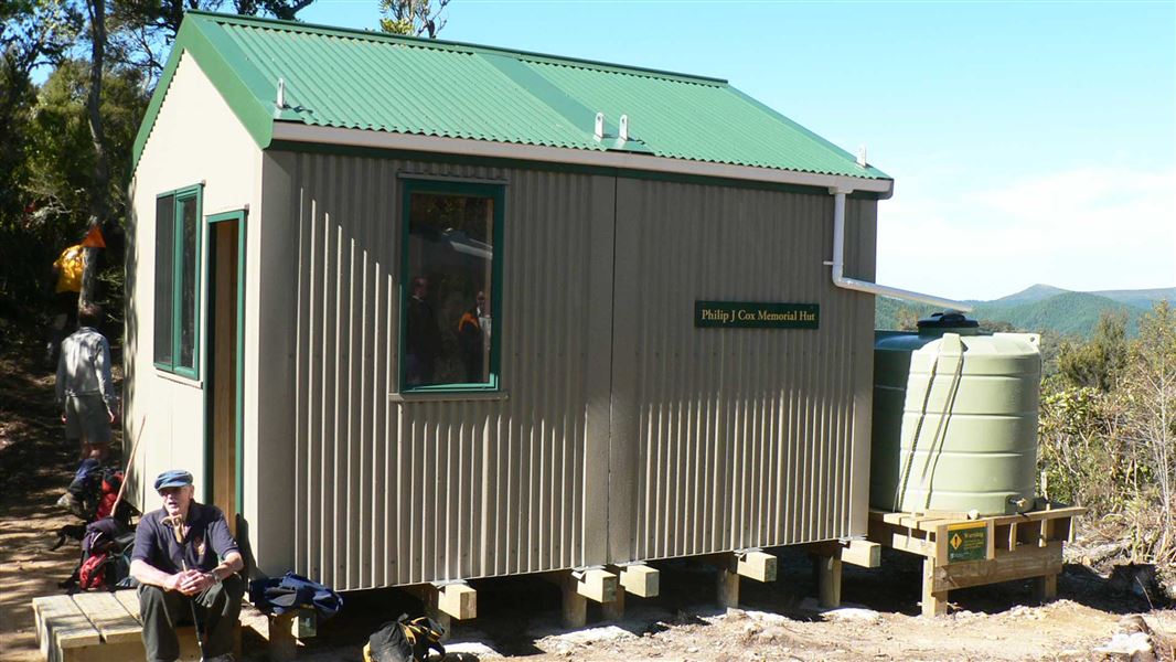
Philip J Cox Memorial Hut
Standard hutSilverpeaks Scenic Reserve, OtagoOpen
- Sleeps
- 4 bunks
- Booking
- Not bookable
- Cost
- from $15
- Heating
- None
- Drinking water
- Boil first
- Toilet
- Non-flush
Getting there
We have not checked a road end or car park for this place yet, so we do not give driving directions to it. Check how to get there before you go. Some routes cross private land and need the landowner's permission.
How to get there, on doc.govt.nzAccess is off SH1 at Waitati, north of Dunedin, via Double Hill Road/Mountain Road.
- Topo map
- Topo50 sheet CE17
- Grid reference
- E1405205 N4934942
Source: DOC Te Papa Atawhai.
Map and tracks
Track lines: DOC Te Papa Atawhai. Map data © OpenStreetMap contributors. Topo map: LINZ, CC BY 4.0. 45.71156° S, 170.49725° E
About this place
This is a standard 4 bunk hut in the Coastal Otago area.
On the way here
Silverpeaks Circuit Track · 12 hr
Jubilee Hut to Philip J Cox Memorial Hut
Time: 3 hr 50 min
7.7 km From the hut you must return down the track to rejoin the Silverpeaks Circuit Track. You will immediately cross a creek and climb steeply up a face to the next ridgeline. From here the track follows an old 4WD road across the ridgeline before dropping towards the valley floor beneath a large rock formation known locally as 'The Cats Teeth'. Underneath the Cats Teeth, approximately 2.5 km from Jubilee Hut, you will find an intersection marking the side trip to ABC Cave - see below. From the intersection with ABC Cave the track continues along the valley floor before climbing back up to meet Yellow Ridge. From the top of Yellow Ridge, the track descends through tussock and into regenerating native bush before reaching Philip J Cox Memorial Hut. Camping is not available at the hut. The grass area beside it is for helicopter landings and should not be camped on in case of emergency helicopter landings.
Philip J Cox Memorial Hut to Silverpeaks Scenic Reserve car park
Time: 3 hr 45 min
7.5 km From Philip J Cox Memorial Hut the track continues down the ridge through native bush. 400 m from the hut, a new track alignment has been adopted to form a complete circuit within the Silverpeaks Scenic Reserve. Instead of following the old track alignment which exited the reserve via a forestry block, turn right at wooden routed sign named River Track. Continue to follow the wooden routed River Track signs to stay on the new track to complete the circuit and return to the Silverpeaks Scenic Reserve car park. The track follows the South Branch of the Waikouaiti River which you must cross a couple of times. If you keep an eye out, you will be able to see former gold mine workings and water races as well as a beautiful rock pool which is a must see part of the track. This section of track provides a steady gradient most of the way before reaching a final steep climb from the valley floor back to the car park.
Source: DOC Te Papa Atawhai.
Trip options
Walking times come from DOC track descriptions, added up leg by leg from car-accessible trailheads. Nights and return times are ParkUp estimates, allowing about 8 hours of walking a day.
2 options · 1 night
Jubilee Hut
Walking in
3 hr 50 min
Walking out
3 hr 45 min to Silverpeaks Scenic Reserve car park
Walking in
3 hr 50 min
Walking out
3 hr 50 min to Jubilee Hut
Source: DOC Te Papa Atawhai track descriptions.
Fees and bookings
Before you go, buy Hut Tickets for each night's stay. Put these in the honesty box at the hut. Or buy a Backcountry Hut Pass that gives unlimited use at most Standard and Serviced huts for a 12 month period. Retailers that sell hut tickets and passes
Source: DOC Te Papa Atawhai.
Nearby stops

Jubilee Hut
Standard • 10 bunks • Otago • 4.5 km
Jubilee Hut is a standard ten-bunk hut located in the Coastal Otago area. It features two large beds that can accommodate six people, along with drinking water…
Mattresses • Toilets - non-flush • Water from tap - not treated, boil before use
Memorial Hut
8 bunks • Canterbury • 226.3 km
Memorial Hut is a backcountry hut located in the Canterbury region. It provides basic shelter for hikers and tramps passing through the area.
Christmas Creek Hut
Otago • 5 km
Christmas Creek Hut is a backcountry hut located in the Otago region of New Zealand. The provided data does not include further details regarding its specific…
Bendoran Hut
Otago • 6 km
Mount John Hut
Otago • 6.8 km
Mount John Hut is a backcountry hut located in the Otago region of New Zealand. It provides basic shelter for hikers and tramping parties in the area.
Walks nearby
Contact
DOC Customer Service Centre
Regional DOC service centre.
Notes from people who have been
No notes yet. If you have been, say what you found.
Something missing or out of date?
Closed, moved, wrong facts, or something we have missed? Travellers keep the Road Guide up to date. Tell us what you found at contribute@parkup.nz and we will check it and add it.
Ask us to take this down
A person reads every request. We do not remove a place until we have checked it.
Sources
- OpenStreetMap Huts · ODbL (Open Database License)Contains information from OpenStreetMap, made available under the ODbL.
- DOC Huts · CC BY 4.0Data sourced from the Department of Conservation (DOC), New Zealand.
- DOC Huts (API) · CC BY 4.0Crown Copyright: Department of Conservation Te Papa Atawhai. Data sourced from the DOC Developer Portal (api.doc.govt.nz).