Lake Alta Track
WalkOtago
- Grade
- Advanced
- Walking time
- 1 hr 30 min
- Distance
- 2.4 km
- Dogs
- On a lead
Getting there
We have not checked a road end or car park for this place yet, so we do not give driving directions to it. Check how to get there before you go. Some routes cross private land and need the landowner's permission.
How to get there, on doc.govt.nzStarting from the south of the Kawarau River on the eastern side of Lake Wakatipu, turn off SH 6 at the signposted junction to the Remarkables ski area. Drive up the road to the Remarkables skifield. To get there you’ll need to pay a road toll.
Check the road conditions before you go, as there is often snow on the road.
The road is mainly sealed but the last 3km are gravel. There are steep drops beside the road.
Road toll info and road weather conditions (external site).
Source: DOC Te Papa Atawhai.
Map
Map data © OpenStreetMap contributors. Topo map: LINZ, CC BY 4.0. 45.05987° S, 168.81689° E
About this place
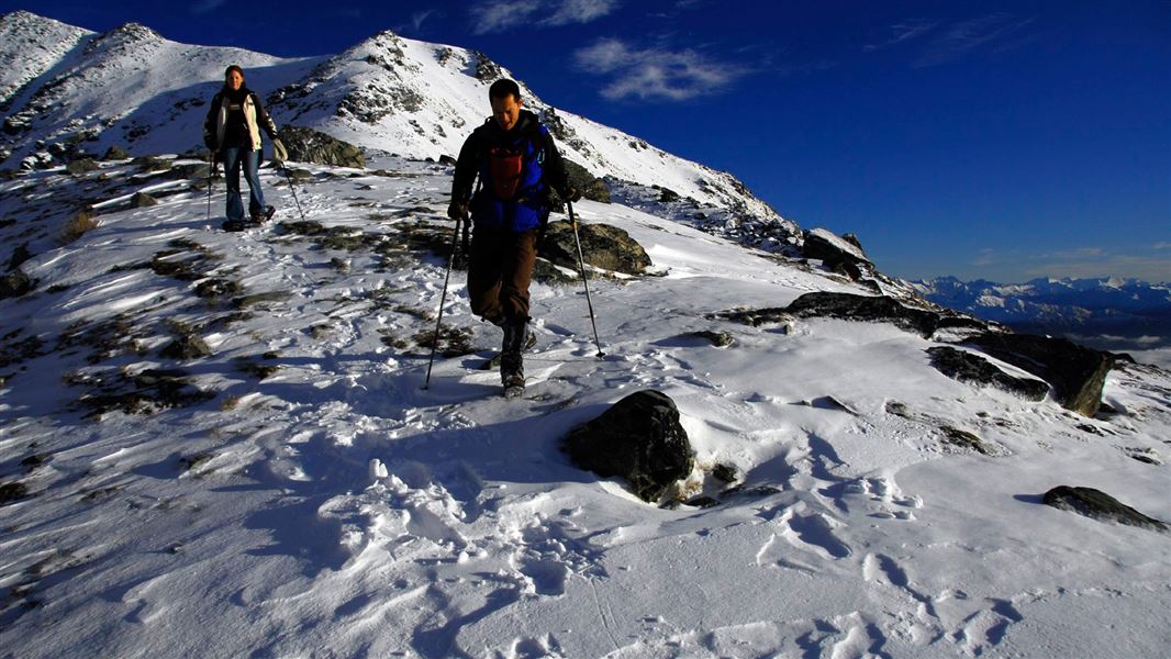
Climb to the picturesque glacial Lake Alta. In winter the route to the lake is through an operational ski field. It is not marked and covered by deep snow.
The route
This walk climbs steadily to a picturesque glacial lake. There are information boards explaining the environment on the last part of the walk. The track begins on the road behind the Remarkables ski field buildings and follows a ski field road to the top of the Alta Chairlift. From there, cairns and flagstones mark the way through alpine wetlands, up to the glacial cirque. Keep to the track to avoid damaging the rare alpine plants. The track is high up (starts at 1600m, ends at 1800m) – this means it is cold all year and there can be snow at any time. Check the forecast before you go and pack warm, waterproof clothes.
Lake Alta route in winter (May to November)
There is deep snow in this area in winter and spring (generally May to November). The track is covered by snow and you cannot easily see it or walk on it. We strongly recommend snowshoes and poles. It will be very hard to make your way through the snow to Lake Alta without these. The Lake Alta route passes through a working ski field. If you want to try this trip in winter, you need to contact NZSki to ask about what route to take (www.NZSki.co.nz or call 0800 697 547). There is no formed track in winter (as it is covered in snow), so you need to know where you are going and be confident navigating yourself in snow. The ski field web cam will show you the snow conditions that you’d need to walk through. Be aware that there is avalanche risk in the Lake Alta area. Not sure this trip is for you? These walks are all good winter options without snow and with great scenery: Lake Hayes Walkway , Bannockburn Sluicings ,Mt Crichton Loop Track .
Source: DOC Te Papa Atawhai.
Know before you go
What to take
For trips between December and April, take everything on the day hike gear list. For trips between May and November, make sure you also bring: snowshoes, poles, very warm clothing (e.g. alpine/ski gear), waterproof raincoat, waterproof trousers, warm hat, scarf, waterproof gloves, sun/snow glasses and a headtorch.
Check the forecast and be ready for cold temperatures
Lake Alta is high in the mountains and it is often very cold – always bring lots of warm clothing, a waterproof raincoat and extra snacks. Check the forecast here
There is deep snow in winter, you need special gear
Think carefully about whether you want to attempt this track in winter. There is deep snow covering the route, so you need snowshoes and poles plus extra alpine gear. The route is through a working ski field.
Take all your rubbish away with you
There are no rubbish bins. Carry out any rubbish, including dog poo.
Stay on the track to protect alpine plants
This area is home to delicate and threatened alpine plants. Stay on the formed track/route to avoid stepping on them.
Source: DOC Te Papa Atawhai.
Nearby stops

Racemans Hut
Basic/bivvies • 2 bunks • Otago • 5.5 km
Racemans Hut is an historic two-bunk hut located in the Queenstown area of Otago.
Toilets - non-flush • Water from stream • Water supply
The Jardines
Otago • 5.8 km
The Jardines is a campsite located in the Otago region of New Zealand. No further details are available in the provided records.
Service Hub for SC-Vehicles
Otago • 7.3 km
Driftaway Queenstown Holiday Park
Otago • 8.6 km
Driftaway Queenstown Holiday Park is a campsite located in the Otago region. It offers a place to stay for visitors exploring the Queenstown area.
Kawarau Bridge Freedom Camping Area
Otago • 8.7 km
Kawarau Bridge Freedom Camping Area is a campsite located in the Otago region. The provided data does not list specific facilities or additional details for…
Walks nearby
Notes from people who have been
No notes yet. If you have been, say what you found.
Something missing or out of date?
Closed, moved, wrong facts, or something we have missed? Travellers keep the Road Guide up to date. Tell us what you found at contribute@parkup.nz and we will check it and add it.
Ask us to take this down
A person reads every request. We do not remove a place until we have checked it.
Sources
- DOC Tracks (API) · CC BY 4.0Crown Copyright: Department of Conservation Te Papa Atawhai. Data sourced from the DOC Developer Portal (api.doc.govt.nz).