Boyd, Oamaru and Cascade Hut tracks
WalkHawke's Bay
- Grade
- Advanced
- Walking time
- 4 days
- Dogs
- DOC permit only
Access: read before you go
One airstrip and a number of helipads allow light aircraft and helicopter access into the park. A permit is required to land at Boyd Airstrip and designated helicopter landing sites. Find commercial operators who fly in recreational users | Find out how to provide aircraft activities on conservation land
Source: DOC Te Papa Atawhai.
Getting there
We have not checked a road end or car park for this place yet, so we do not give driving directions to it. Check how to get there before you go. Some routes cross private land and need the landowner's permission.
How to get there, on doc.govt.nz27 km east of Taupo turn right off SH5 (Napier Taupo Road) into Taharua Road and follow for 9.5 km. Turn right into Clements Mill Road - it is 21 km to the end of this road.
One airstrip and a number of helipads allow light aircraft and helicopter access into the park. A permit is required to land at Boyd Airstrip and designated helicopter landing sites. Find commercial operators who fly in recreational users | Find out how to provide aircraft activities on conservation land
Source: DOC Te Papa Atawhai.
Map
Map data © OpenStreetMap contributors. Topo map: LINZ, CC BY 4.0. 39.03180° S, 176.21368° E
About this place
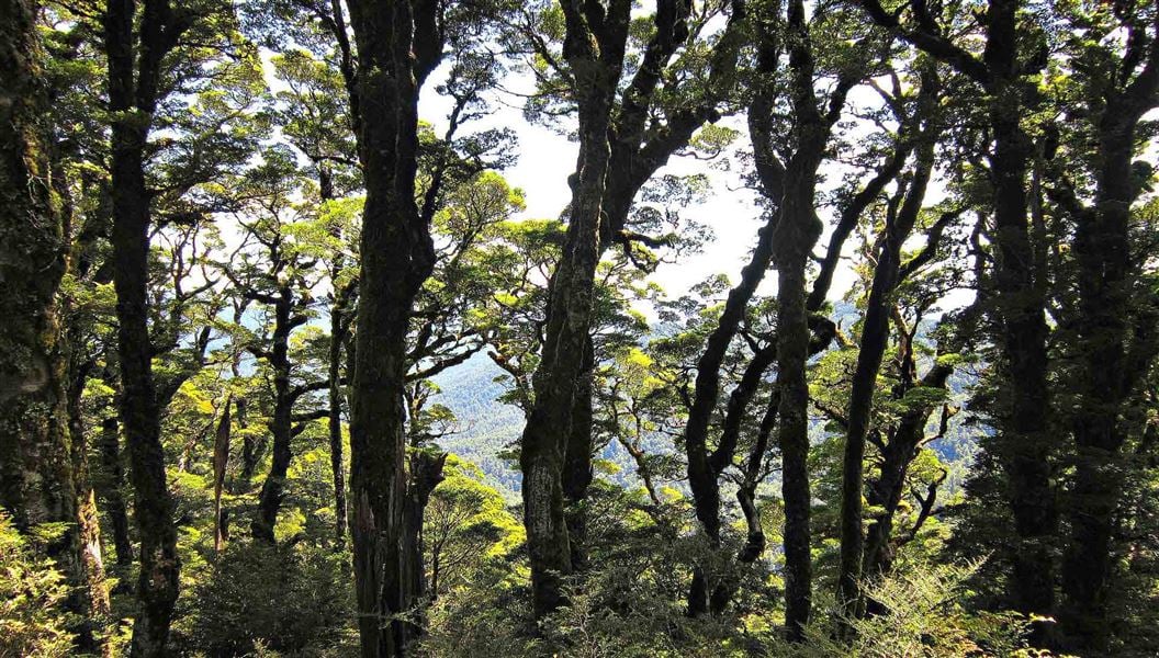
Combine these tracks for a multi-night tramp with lush beech forest, river crossings and wildlife. Several huts and road ends allow you to tailor a trip to suit.
The route
Clements Mill Road to Oamaru Hut via Te Iringa
Time: 6 - 8 hr
km This track leaves from the car park 5 km along Clements Mill Road. It climbs to a clearing where the Te Iringa Hut used to be (1-2 hours), then skirts around Mt Te Iringa (1241 m), before dropping down to the Tikitiki Stream/Kaipo River junction where the track forks at a swingbridge. Take the main track straight ahead and follow the true right of the Kaipo River down to Oamaru Hut, situated near the confluence of the Kaipo and Oamaru rivers. Note, Te Iringa Hut has burnt down and will not be replaced. It may show on older maps. Be aware, mountain bikes are also permitted on this track.
Taharua Road to Oamaru Hut
Time: 4 hr
km Park in the car park beside the helicopter hanger at the Taharua roadend. Follow the poled route through Poronui Station. From near the Mohaka River a new track links from the end of the poled route to Oamaru Hut via a crossing of the Kaipō River. As a condition of access through Poronui Station absolutely no hunting or mountain bikes allowed. Hunters must remove rifle bolts. Fishing is allowed with marked side tracks to the Taharua River. Excellent trout fishing can be had in the Taharua stream, which can be accessed from the poled route. There is also excellent fishing on the Oamaru and Kaipo streams which are easily accessed from Oamaru Hut.
Oamaru Hut - Boyd Hut
Time: 4 - 6 hr
km From Oamaru Hut the track follows the true left bank of the Oamaru River before crossing the headwaters and following the Waitawhero Stream up to a saddle. At this point the track emerges at the forest edge of the upper Ngaruroro. Across the valley the Boyd airstrip can be seen. Boyd Hut is obscured by beech forest behind the airstrip.
Boyd Hut to Cascade Hut via Maungaorangi
Time: 10 - 12 hr
km This strenuous track from Boyd Hut follows the track over Waitawhero Saddle towards Oamaru Hut. Near the confluence of the Waitawhero and Oamaru streams the route turns left onto a long, steep ridge up Maungaorangi. On the tops the route is marked with poles. It then descends to Te Waiotupuritia Saddle and on down to Cascade Hut. A map and compass are essential. GPS recommended.
Te Iringa / Oamaru Hut Track - Cascade Hut (Upper Kaipo Valley Route / Kaipo Track)
Time: 6 - 9 hr
km A marked route runs from the swingbridge on the Te Iringa/Oamaru Track to Cascade Hut. In the upper reaches of the Kaipo River there are numerous river crossings and log jams to negotiate, so be aware that this is a time-consuming section. The track then climbs to a ridge just south of Kaipo Saddle. Descend off the ridge to Cascade Stream and the track junction. The right-hand track heads downstream for another 30 minutes to Cascade Hut.
Cascade Hut to Clements Mill Road (Hinemaiaia Track)
Time: 4 - 5 hr
km The track follows the open river flats of the Tauranga-Taupo River downstream before climbing away from the river up a prominent beech-covered ridge. The track drops down to the Clements Mill roadend following the Hinemaiaia Stream and its tributaries. Heading in for a night at the Cascade Hut via the Hinemaiaia Track PHOTO: Anna Elwarth | DOC
Source: DOC Te Papa Atawhai.
Know before you go
Vehicle access
Clements Mill Road is suitable for small caravans only. Access can be affected by fallen trees during high winds.
Source: DOC Te Papa Atawhai.
On this track
In walking order.


Nearby stops
Poronui Hut
Hawke's Bay • 7.2 km
Clements Road End Campsite
Waikato • 7.8 km
Clements Road End Campsite is a basic campsite located in the Tūrangi and Taupō area of the Waikato region. The site is situated at the start of the Hinemaiaia…

Te Iringa Campsite
Basic • Waikato • 8.3 km
Te Iringa Campsite is located in the Waikato region at the start of the Te Iringa Track. The track is popular for hunting, tramping, and mountain biking.
Fire pit/place for campfires (except in fire bans) • Non-powered/tent sites • Toilets - non-flush

Army Road Campsite
Basic • Waikato • 8.7 km
Army Road Campsite is a campsite in the Waikato region. It is situated in an area of diverse terrain where visitors can enjoy hunting, walking, fishing, and…
Fire pit/place for campfires (except in fire bans) • Non-powered/tent sites • Water from stream
Red Hut
Hawke's Bay • 9 km
Red Hut is a backcountry hut located in the Hawke's Bay region. It provides basic shelter for hikers and trappers in the area.
Notes from people who have been
No notes yet. If you have been, say what you found.
Something missing or out of date?
Closed, moved, wrong facts, or something we have missed? Travellers keep the Road Guide up to date. Tell us what you found at contribute@parkup.nz and we will check it and add it.
Ask us to take this down
A person reads every request. We do not remove a place until we have checked it.
Sources
- DOC Tracks (API) · CC BY 4.0Crown Copyright: Department of Conservation Te Papa Atawhai. Data sourced from the DOC Developer Portal (api.doc.govt.nz).