Boyd Hut
Standard hutKaimanawa Forest Park, Hawke's BayOpen
- Sleeps
- 16 bunks
- Booking
- Not bookable
- Cost
- from $15
- Heating
- Yes
- Drinking water
- Boil first
- Toilet
- Non-flush
Getting there
We have not checked a road end or car park for this place yet, so we do not give driving directions to it. Check how to get there before you go. Some routes cross private land and need the landowner's permission.
How to get there, on doc.govt.nz- Topo map
- Topo50 sheet BH36
Source: DOC Te Papa Atawhai.
Map and tracks
Track lines: DOC Te Papa Atawhai. Map data © OpenStreetMap contributors. Topo map: LINZ, CC BY 4.0. 39.15536° S, 176.16858° E
About this place
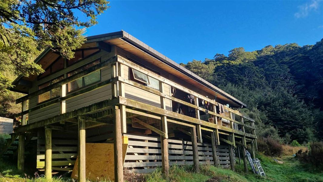
This is a standard 16-bunk hut in the Kaimanawa Forest Park, nestled below the Boyd Rocks looking over the Ngaruroro Valley.
On the way here
Boyd, Oamaru and Cascade Hut tracks · 2 - 4 days
Oamaru Hut - Boyd Hut
Time: 4 - 6 hr
km From Oamaru Hut the track follows the true left bank of the Oamaru River before crossing the headwaters and following the Waitawhero Stream up to a saddle. At this point the track emerges at the forest edge of the upper Ngaruroro. Across the valley the Boyd airstrip can be seen. Boyd Hut is obscured by beech forest behind the airstrip.
Boyd Hut to Cascade Hut via Maungaorangi
Time: 10 - 12 hr
km This strenuous track from Boyd Hut follows the track over Waitawhero Saddle towards Oamaru Hut. Near the confluence of the Waitawhero and Oamaru streams the route turns left onto a long, steep ridge up Maungaorangi. On the tops the route is marked with poles. It then descends to Te Waiotupuritia Saddle and on down to Cascade Hut. A map and compass are essential. GPS recommended.
Source: DOC Te Papa Atawhai.
Trip options
Walking times come from DOC track descriptions, added up leg by leg from car-accessible trailheads. Nights and return times are ParkUp estimates, allowing about 8 hours of walking a day.
2 options · 2 to 3 nights
Taharua Road
Walking in
10 hr (via Oamaru Hut)
Walking out
10 hr to Taharua Road (via Oamaru Hut)
Walking in
10 hr (via Oamaru Hut)
Walking out
12 hr to Cascade Hut via Maungaorangi
Source: DOC Te Papa Atawhai track descriptions.
Fees and bookings
Source: DOC Te Papa Atawhai.
Nearby stops

Cascade Hut
Standard • 6 bunks • Waikato • 11.9 km
Cascade Hut is a standard six-bunk hut located in the Kaimanawa Forest Park in the Waikato region. It serves as a base for hunters and hikers exploring the…
Heating • Mattresses • Toilets - non-flush

Oamaru Hut
Standard • 12 bunks • Hawke's Bay • 12.2 km
Oamaru Hut is a standard 12-bunk hut located in the Kaimanawa Forest Park. It serves as a base for hunting sika deer and fishing.
Heating • Mattresses • Toilets - non-flush
Te Whare Ruruhau
Hawke's Bay • 3.3 km
Te Whare Ruruhau is a hut located in the Hawke's Bay region. No further details are available in the provided records.

Tussock Hut
Standard • 6 bunks • Hawke's Bay • 4.2 km
Tussock Hut is a hut located in Hawke's Bay. It sits at the upper northern end of Tussock Valley, on a tributary of Ngaawapurua (Harkness) Stream.
Heating • Mattresses • Toilets - non-flush
Gold Creek Hut
Hawke's Bay • 4.6 km
Contact
DOC Customer Service Centre
Regional DOC service centre.
Notes from people who have been
No notes yet. If you have been, say what you found.
Something missing or out of date?
Closed, moved, wrong facts, or something we have missed? Travellers keep the Road Guide up to date. Tell us what you found at contribute@parkup.nz and we will check it and add it.
Ask us to take this down
A person reads every request. We do not remove a place until we have checked it.
Sources
- DOC Huts (API) · CC BY 4.0Crown Copyright: Department of Conservation Te Papa Atawhai. Data sourced from the DOC Developer Portal (api.doc.govt.nz).
- DOC Huts · CC BY 4.0Data sourced from the Department of Conservation (DOC), New Zealand.
- OpenStreetMap Huts · ODbL (Open Database License)Contains information from OpenStreetMap, made available under the ODbL.