Wether Range tracks
WalkCanterburyOpen
- Grade
- Expert
- Walking time
- 2 hr
- Distance
- 3 or 6.5 km
- Dogs
- No dogs
Getting there
We have not checked a road end or car park for this place yet, so we do not give driving directions to it. Check how to get there before you go. Some routes cross private land and need the landowner's permission.
How to get there, on doc.govt.nzThese access points are off SH8, 12 and 16 km south of Omarama.
Source: DOC Te Papa Atawhai.
Map
Map data © OpenStreetMap contributors. Topo map: LINZ, CC BY 4.0. 44.52750° S, 169.76892° E
About this place
The Wether Range tracks are found south of Omarama.
The route
Shortcut Road to Wether Range Conservation Area
Time: 2 hr
Track category: Tramping track 6.5 km Follow a public access easement through private farmland along the fenceline boundary. Once in the conservation area, there is no formed track. A diverse selection of native scrub covers the flats near Manuka Creek which runs through here. Turn off SH8 into Shortcut Road, 12 km south of Omarama. A sign along Shortcut Road shows the start of the track. Native scrub in Wether Range Conservation Area
SH8 to Wether Range Conservation Area
Time: 1.5 hr
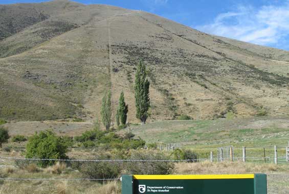
Track category: Route km There is no formed track but follow the DOC markers on the steep fenceline boundary to the conservation area. This is a public access easement through private farmland. This route is signposted off SH8, 16 km south of Omarama. Access route along the fenceline (centre) to Wether Range Conservation Area
Source: DOC Te Papa Atawhai.
Nearby stops
Freedom Camping spot
Canterbury • 3.5 km
This freedom camping spot is located in the Canterbury region. No specific facilities or additional details are provided in the available records.
Tin Hut
5 bunks • Canterbury • 16.7 km
Tin Hut is a basic shelter located in the Canterbury region of New Zealand. It provides a simple place to stay for outdoor enthusiasts in the area.
Walks nearby
Notes from people who have been
No notes yet. If you have been, say what you found.
Something missing or out of date?
Closed, moved, wrong facts, or something we have missed? Travellers keep the Road Guide up to date. Tell us what you found at contribute@parkup.nz and we will check it and add it.
Ask us to take this down
A person reads every request. We do not remove a place until we have checked it.
Sources
- DOC Tracks & Trails · CC BY 4.0Data sourced from the Department of Conservation (DOC), New Zealand.
- DOC Tracks (API) · CC BY 4.0Crown Copyright: Department of Conservation Te Papa Atawhai. Data sourced from the DOC Developer Portal (api.doc.govt.nz).