Tangihua Hut
Standard hutTangihua Forest, NorthlandOpen
- Sleeps
- 8 bunks
- Booking
- Not bookable
- Cost
- from $15
- Heating
- None
- Drinking water
- Boil first
- Toilet
- Non-flush
Getting there
We have not checked a road end or car park for this place yet, so we do not give driving directions to it. Check how to get there before you go. Some routes cross private land and need the landowner's permission.
How to get there, on doc.govt.nzAccess the Tangihua Forest via Omana Road.
From the Omana Road access car park, you will need to walk 30 minutes along a formed road to the bush line. From here, it is another 15 minutes until you reach Lions Lodge.
To reach the Tangihua hut from the Lodge follow the Te Haua Uru Track which turns into the Northern Tangihua Route. This will take 8–9 hr.
The land between Tangihua Forest and Tangihua Road is private land. You must get permission to cross over private land. Contact 0800 ASK DOC (0800 275 362) to get the landowner's details. No dogs or firearms are allowed on this private property.
- Topo map
- Topo50 sheet AX29
Source: DOC Te Papa Atawhai.
Map and tracks
Track lines: DOC Te Papa Atawhai. Map data © OpenStreetMap contributors. Topo map: LINZ, CC BY 4.0. 35.85045° S, 174.11047° E
About this place
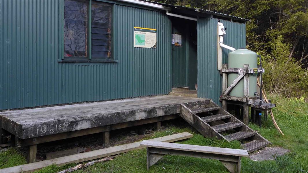
Tangihua Hut is an eight-bunk standard hut.
On the way here
Te Haua Uru Track · 3 hr 45 min to junction one way from car park
From the Tangihua Lions Lodge you walk past the orientation course and clearings to enter a bush track. For your own safety keep off the orientation course equipment - it's supplied by the Lions Lodge Trust for the use of their guests with appropriate safety equipment and supervision. The track crosses a stream via a small bridge and meets the Tumanako Track . Signage directs you to follow the stream for approximately 20 minutes before crossing it and heading up towards a kauri grove, traversing up through mixed podocarp/broadleaf forest. Within 20 minutes you will reach the large kauri trees at Kauri Grove. From here the Te Haua Uru Track continues to climb steeply up to the junction of the Tangihua Main Ridge Track which leads to the Horokaka Transmitter (an additional 2 - 3 hours tramp) and the Northern Tangihua Track which leads to the Tangihua Hut (an additional 2 - 3 hours tramp). Both tracks are strenuous and require tramping experience due to the roughness of the routes. Day walkers can easily walk as far as Kauri Grove accessed from the Te Haua Uru Track. Experienced trampers wanting a challenging day can follow the Te Haua Uru Track-Tangihua Main Ridge Track- Horokaka Track loop, a full 9 hour tramp which includes strenuous climbing in places. Alternatively they can continue on to the Tangihua Hut via the Northern Tangihua Track.
Main Ridge Track · 2 - 3 hr one way
which leads to the Tangihua Hut, a further 2-3 hours tramp from the Main Ridge Route – Te Haua Uru intersection.
Source: DOC Te Papa Atawhai.
Fees and bookings
Before you go, buy Hut Tickets for each night's stay. Put these in the honesty box at the hut. Or buy a Backcountry Hut Pass that gives unlimited use at most Standard and Serviced huts for a 12 month period. Retailers that sell hut tickets and passes
Source: DOC Te Papa Atawhai.
On these tracks
Source: DOC Te Papa Atawhai.
Walks nearby
Contact
DOC Customer Service Centre
Regional DOC service centre.
Notes from people who have been
No notes yet. If you have been, say what you found.
Something missing or out of date?
Closed, moved, wrong facts, or something we have missed? Travellers keep the Road Guide up to date. Tell us what you found at contribute@parkup.nz and we will check it and add it.
Ask us to take this down
A person reads every request. We do not remove a place until we have checked it.
Sources
- DOC Huts (API) · CC BY 4.0Crown Copyright: Department of Conservation Te Papa Atawhai. Data sourced from the DOC Developer Portal (api.doc.govt.nz).
- OpenStreetMap Huts · ODbL (Open Database License)Contains information from OpenStreetMap, made available under the ODbL.
- DOC Huts · CC BY 4.0Data sourced from the Department of Conservation (DOC), New Zealand.