Maude Track to Mangakotukutuku Falls
WalkTaranaki
- Grade
- Advanced
- Walking time
- 1 hr 30 min
- Distance
- 2.8 km
- Dogs
- No dogs
Getting there
We have not checked a road end or car park for this place yet, so we do not give driving directions to it. Check how to get there before you go. Some routes cross private land and need the landowner's permission.
How to get there, on doc.govt.nzThe track begins at the end of Maude Road, around twenty minutes’ drive from New Plymouth.
Drive south from New Plymouth on State Highway 3 (signs towards Inglewood and Whanganui). Turn right onto Kent Road, then turn right onto Maude Road and follow it to the end. Car parking at the end of the road is limited.
Source: DOC Te Papa Atawhai.
Map
Map data © OpenStreetMap contributors. Topo map: LINZ, CC BY 4.0. 39.21507° S, 174.07749° E
About this place
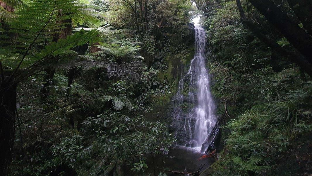
Maude Track leads from the end of Maude Road to the pretty Mangakotukutuku Falls.
The route
Maude Track begins at the end of Maude Road. From the road end the track crosses farmland to the boundary of Te Papa-Kura-o-Taranaki. From here it climbs a ridge on the Pouākai Range through stands of regenerating and ancient forest, before turning left and dropping into the Mangakotukutuku stream valley. You’ll then arrive at the Mangakotukutuku Falls.
Source: DOC Te Papa Atawhai.
Know before you go
Respect private farmland
This track passes through private farmland. Please leave gates as you find them and stay on the route.
Be ready for rain and cold
Taranaki is famous for its fast-changing and extreme weather. Check the forecast before you go and be prepared for rain and cold, even in summer. Be ready for any weather by packing a waterproof jacket and plenty of warm layers. Wear sturdy, comfortable shoes (tramping boots are recommended). What to pack for a day trip
Source: DOC Te Papa Atawhai.
Nearby stops
Kaiauai Shelter
Taranaki • 2.8 km
Kaiauai Shelter is a hut located in the Taranaki region. The provided data does not include further details regarding its facilities or specific location.
Pouākai Hut
16 bunks • Taranaki • 4.1 km
Heating • Mattresses • Toilets - non-flush
Volcanoview Campsite
Taranaki • 5.8 km
Volcanoview Campsite is a campsite located in the Taranaki region of New Zealand. The available records provide no further details regarding specific…
North Egmont Retreat
Taranaki • 6 km

Holly Hut
Serviced • 32 bunks • Taranaki • 6.2 km
Holly Hut is a 32-bunk serviced hut located in the Taranaki region. It serves as a gateway to the spectacular features of Te Papa-Kura-o-Taranaki.
Heating • Mattresses • Lighting
Walks nearby
Waiwhakaiho Route
Expert • 2 hr 30 min • 5 km • 3.03 km away
Pouākai Circuit
Advanced • 2 - 3 days • 25 km • 3.4 km away
Mangorei Track to Pouākai tarns
Intermediate • 2 hr 30 min one way • 5 km • 3.47 km away
Pouākai Crossing
Advanced • 7 hr 30 min - 9 hr 30 min • 19 km • 4 km away
Kōkōwai Track round trip
Advanced • 6 hr • 12 km • 4.97 km away
Notes from people who have been
No notes yet. If you have been, say what you found.
Something missing or out of date?
Closed, moved, wrong facts, or something we have missed? Travellers keep the Road Guide up to date. Tell us what you found at contribute@parkup.nz and we will check it and add it.
Ask us to take this down
A person reads every request. We do not remove a place until we have checked it.
Sources
- DOC Tracks (API) · CC BY 4.0Crown Copyright: Department of Conservation Te Papa Atawhai. Data sourced from the DOC Developer Portal (api.doc.govt.nz).
- OpenStreetMap Trails · ODbL (Open Database License)Contains information from OpenStreetMap, made available under the ODbL.