Kauaeranga Kauri Trail (Pinnacles Walk)
WalkWaikato
- Grade
- Intermediate
- Walking time
- 3 hr
- Distance
- 6 km
- Dogs
- No dogs
Getting there
We have not checked a road end or car park for this place yet, so we do not give driving directions to it. Check how to get there before you go. Some routes cross private land and need the landowner's permission.
How to get there, on doc.govt.nzFrom SH25 at the southern entrance to Thames, turn right into Banks Street beside the service station. Banks Street veers right into Parawai Road, which then becomes Kauaeranga Valley Road.
Follow this for 13 km to the Kauaeranga Visitor Centre. The road continues unsealed a further 9 km to the road end. This is where the track starts.
Source: DOC Te Papa Atawhai.
Map and tracks
Track lines: DOC Te Papa Atawhai. Map data © OpenStreetMap contributors. Topo map: LINZ, CC BY 4.0. 37.04720° S, 175.70099° E
About this place
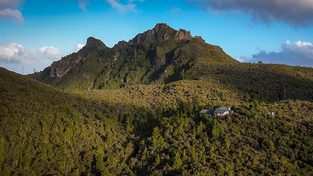
This popular walk leads to Pinnacles Hut, and on to the summit of the Pinnacles with spectacular views of the Coromandel Peninsula. It can be completed as a day or overnight walk.
The route
Walk to Pinnacles Hut and summit as a day or overnight walk. Follow an historic packhorse route used by kauri bushmen in 1920s. There are spectacular views of the Coromandel Peninsula from the Pinnacles lookout (759 m).
Kauaeranga Road end – Hydro Camp via Webb Creek Track – Pinnacles Hut
Time: 2 hr 30 min – 3 hr one way
km From the road end car park, walk to the swing bridge to cross the Kauaeranga River. Take the first track on your right which leads you for 5 minutes to Billygoat Landing. Here you see good views of the Billygoat Falls (180 m high). Second on your right you keep follow the Webb Creek Track to Hydro Camp (1 hr 30 min – 2 hr). You'll climb steps that were cut into rock to make the journey easier for the packhorses during the kauri logging era. Care is required in places as the rocks can be slippery. At the top of the climb to the Hydro Camp clearing, the remains of a skidded road are visible beside the track. Skidded roads were made from small logs laid lengthwise with cross pieces forming the ‘skids’. Logs were pulled along the skids by teams of bullocks or steam haulers. From Hydro Camp junction, take the Pinnacles Track which climbs and sidles around a hill before following a more open ridge. Enjoy impressive views down a branch of the Tairua River and the rugged volcanic landforms of Tauranikau and the Pinnacles. Pinnacles Hut and Dancing Camp Campsite are a short walk down signposted side tracks. At the Dancing Camp Campsite, look for the remains of the Dancing Camp Dam, built in 1921. This stringer flume dam was the second largest dam in the valley, and was partly restored in 1994. Return the same way, or return to the Hydro Camp and take the Billygoat Track back to the road end.
Side trip: Pinnacles Hut – Pinnacles
Time: 40 min one way
km The track up to the Pinnacles is more difficult and exposed than the track to the hut. It is better not to attempt the track in high wind or rain. Assess the weather before deciding whether to continue up to the Pinnacles. A steady climb, steep in places, follows a well constructed stepped track. The final stage of the ascent includes climbing ladders and there are steep drops beside the track. At the Pinnacles summit (759 m) there are spectacular views of the bush, mountains and coastline of the eastern Coromandel. Stay within the fenced summit platform (the rock is fractured and very unstable, and there are steep drops). Be careful when descending back from the lookout to the hut – this is when most injuries on the track occur.
Hydro Camp – Kauaeranga Road end via Billygoat Track
From the Hydro Camp, a steady 30-minute climb leads to a saddle with excellent views down the Kauaeranga Valley to the Hauraki Plains. A little further on, a knoll overlooks the Billygoat Basin. The first attempt to log this basin was made in the 1880s but was abandoned within a few years as driving logs down the Billygoat Falls proved too destructive. The basin was successfully logged in the 1920s after the construction of the Billygoat incline to bypass the falls, and the use of a steam hauler. Drop down into Billygoat Basin and cross Billygoat Stream before passing through a clearing with basic camping facilities. A few minutes further on, a 50 m sidetrack overlooks the site of the collapsed long trestle bridge, once part of the bush tramline. The trestle was 160 m long and 11 m above the ground at the highest point. Back on the main Billygoat walking track, pass the junction for the Tarawaere and Hihi tramping tracks and follow the tramline through deep cuttings past two short trestles. Near the hauler site at the top of the incline there are good views of Billygoat Falls (180 m). From here it is another 40 min downhill to the Kauaeranga Valley Road which requires crossing the Kauaeranga River to the Tarawaere car park. Walk 300 m north along the road to get back to the road end car park.
Flood detour
There is no flood detour at the end of the walk crossing the main Kauaeranga River. You must walk across the river. In high rainfall or flood events use the Webb Creek route only.
Understand if you are ready for the Kauaeranga Kauri Trail
Watch the NZ Mountain Safety Council’s walk-through video which takes you through how to prepare for this track. Including facilities, key decision points, hazards and typical conditions for the area.
Source: DOC Te Papa Atawhai.
Know before you go
Thefts from vehicles
Isolated carparks are prone to theft. Don't leave any valuables in your vehicle. A bag storage facility is available at the Kauaeranga Visitor Centre.
Heavy rain floods the track and access road
The track and access road flood during large storms and heavy rain. This can happen at any time of year but is most common in Spring. We strongly advise that you do not attempt to walk the track or drive the road at these times. Check the weather for Pinnacles Hut
Take care when crossing streams and rivers
There are unbridged streams on the Pinnacles Track and Billygoat Track. Billygoat Track also ends with an unbridged crossing of the Kauaeranga River. These can be dangerous during/after heavy rain. Assess them carefully before crossing and if in doubt, stay out. Learn about river crossing on the MSC website , including the signs of an unsafe river. Cookson Kauri Walk is a good wet weather alternative.
Pack well, even for a day walk
Be ready for all weather by carrying warm layers, a waterproof raincoat, sun protection and 3L of water per person (the hut supply can run dry). The track is extremely slippery in places, so you need sturdy shoes with good grip. Sneakers are not suitable for this track. For an overnight trip, find a packing list here. The Pinnacles Track is a long day walk. You need everything on the day hikes packing list . Leave early and pack a torch in case the track takes longer than planned. Pack a communication device, a distress beacon is best.
Source: DOC Te Papa Atawhai.
On this track
In walking order.

Nearby stops

Dancing Camp Campsite
Backcountry • Waikato • 1.2 km
Dancing Camp Campsite is located on the Kauaeranga Kauri Trail in the Coromandel. It sits near the historic Dancing Camp kauri driving dam.
Water from tap - not treated, boil before use • Toilets - non-flush • Toilets

Pinnacles Hut
Serviced • 80 bunks • Waikato • 1.2 km
Pinnacles Hut is a serviced 80-bunk hut in the Coromandel area. Bookings must be made online in advance.
Cooking • Heating • Mattresses
Billygoat Basin Campsite
Backcountry • Waikato • 2.6 km
Billygoat Basin Campsite is a campsite located on the popular Billygoat Circuit in the Coromandel region.
Water from stream • Toilets - non-flush • Toilets

Moss Creek Campsite
Backcountry • Waikato • 3.1 km
Moss Creek Campsite is a backcountry campsite located on the Moss Creek Track in the Coromandel region.
Toilets - non-flush • Toilets
Trestle View Campsite
Standard • Waikato • 3.7 km
Trestle View Campsite is a scenic campsite located at the end of the Kauaeranga Valley in the Coromandel. It is the closest campsite to the start of the Webb…
Non-powered/tent sites • Water from stream • Toilets - non-flush
Walks nearby
Something missing or out of date?
Closed, moved, wrong facts, or something we have missed? Travellers keep the Road Guide up to date. Tell us what you found at contribute@parkup.nz and we will check it and add it.
Ask us to take this down
A person reads every request. We do not remove a place until we have checked it.
Sources
- DOC Tracks (API) · CC BY 4.0Crown Copyright: Department of Conservation Te Papa Atawhai. Data sourced from the DOC Developer Portal (api.doc.govt.nz).