Crosbies Hut
Serviced hutCoromandel Forest Park, WaikatoOpen
- Sleeps
- 10 bunks
- Booking
- Can book
- Cost
- from $28
- Heating
- Yes
- Drinking water
- Boil first
- Toilet
- Non-flush
Getting there
We have not checked a road end or car park for this place yet, so we do not give driving directions to it. Check how to get there before you go. Some routes cross private land and need the landowner's permission.
How to get there, on doc.govt.nzCrosbies Hut is located on the Memorial Loop Track off the Main Range Track, approximately 12 km north-east of Thames.
The tramping track from the Kauaeranga Valley to Crosbies Hut has been re-routed from Whangaiterenga Campsite to Booms Flat Campsite. The Whangaiterenga route still shows on the NZ Topo Map. Be aware it is now accessed from Booms Flat.
The hut can be accessed from six tracks.
- Topo map
- Topo50 sheet BB35
- Grid reference
- E1831356 N5896874
Source: DOC Te Papa Atawhai.
Map and tracks
Track lines: DOC Te Papa Atawhai. Map data © OpenStreetMap contributors. Topo map: LINZ, CC BY 4.0. 37.04602° S, 175.60197° E
About this place
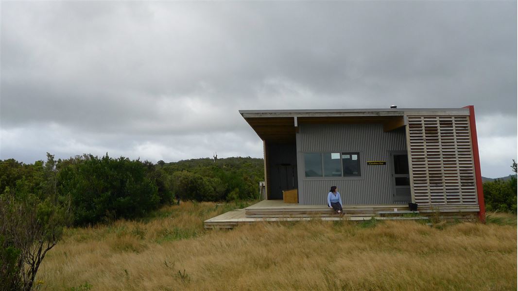
This is a serviced 10-bunk backcountry hut in the Coromandel area. The hut must be booked online in advance.
On the way here
Booms Tramping Track
junction. From there, it's about a further 30 min to Crosbies Hut. Alternatively, you can follow the Karaka Track for around 4.5 hr down to Thames.
Te Puru Track · Over 4 hours
This track joins with Tapu summit to Crosbies Hut Track to reach Crosbies Hut.
The track starts from Te Puru and rises steeply until it meets the top ridge. It is around one hour from the top of the ridge until Crosbies Hut.
Source: DOC Te Papa Atawhai.
Fees and bookings
1 May - 30 September
1 October - 30 April
Weekdays
Weekends
1 December - 29 February
Weekdays
Weekends
Backcountry Hut Passes can be used at this hut. About hut tickets and passes Retailers that sell hut tickets and passes
Bookings are open for stays up to 30 June 2027. If no availability shows online for your dates, the hut is fully booked. No spaces are kept for visitors arriving without a booking. Phone and in‑person bookings made at a visitor centre incur a $10 service fee. Same‑day bookings are available online until 8 pm if spaces remain. Book Crosbies Hut online .
Source: DOC Te Papa Atawhai.
On these tracks
Source: DOC Te Papa Atawhai.
Nearby stops

Crosbies Hut Backcountry Campsite
Backcountry • Waikato • 0 km
Crosbies Hut Backcountry Campsite is a backcountry campsite located outside Crosbies Hut in the Coromandel region of the Waikato.
Water from tap - not treated, boil before use • Toilets - non-flush • Toilets

Booms Flat Campsite
Standard • Waikato • 5.6 km
Booms Flat Campsite is a spacious campsite located in the Kauaeranga Valley, 6 km north of the visitor centre.
Non-powered/tent sites • Water from stream • Toilets - non-flush

Wainora Campsite
Standard • Waikato • 5.7 km
Wainora Campsite is located in the Coromandel and serves as the starting point for the Cookson Kauri Walk. The walk features attractive water views along its…
Non-powered/tent sites • Water from stream • Toilets - non-flush

Whangaiterenga Campsite
Standard • Waikato • 5.7 km
Whangaiterenga Campsite is located in the Coromandel near the confluence of the Whangaiterenga Stream and the Kauaeranga River. A one hour return walk from the…
Non-powered/tent sites • Toilets - flush • Water from stream

Catleys Campsite
Standard • Waikato • 5.9 km
Catleys Campsite is a riverside campsite located 6 km north of the Kauaeranga visitor centre in the Coromandel region.
Non-powered/tent sites • Water from stream • Toilets - non-flush
Walks nearby
Contact
Kauaeranga Visitor Centre
Regional DOC service centre.
Notes from people who have been
No notes yet. If you have been, say what you found.
Something missing or out of date?
Closed, moved, wrong facts, or something we have missed? Travellers keep the Road Guide up to date. Tell us what you found at contribute@parkup.nz and we will check it and add it.
Ask us to take this down
A person reads every request. We do not remove a place until we have checked it.
Sources
- DOC Huts · CC BY 4.0Data sourced from the Department of Conservation (DOC), New Zealand.
- DOC Huts (API) · CC BY 4.0Crown Copyright: Department of Conservation Te Papa Atawhai. Data sourced from the DOC Developer Portal (api.doc.govt.nz).
- OpenStreetMap Huts · ODbL (Open Database License)Contains information from OpenStreetMap, made available under the ODbL.