Rangituhi/Colonial Knob Walk
WalkWellington
- Grade
- Easy
- Walking time
- 5 hr
- Dogs
- No dogs
Getting there
We have not checked a road end or car park for this place yet, so we do not give driving directions to it. Check how to get there before you go. Some routes cross private land and need the landowner's permission.
How to get there, on doc.govt.nzThe track starts at the Broken Hill Road carpark at Spicer Botanical Park, or from Raiha Street in Porirua.
Source: DOC Te Papa Atawhai.
Map
Map data © OpenStreetMap contributors. Topo map: LINZ, CC BY 4.0. 41.14682° S, 174.80915° E
About this place
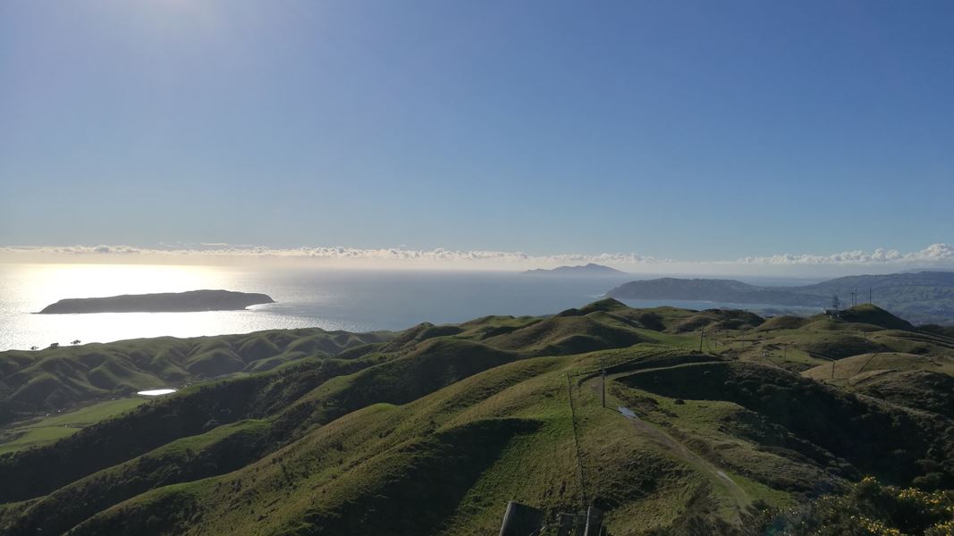
Climb to the summit of this 468 m peak for views on clear day from the Inland Kaikoura Range in the south to Mt Taranaki in the north-west - it's a good option for older children. This track is part of Te Araroa Trail.
The route
This track is part of Te Araroa Trail . There are three routes up to Rangituhi/Colonial Knob, offering a loop walk taking from three to five hours. One starts at the Broken Hill Road carpark (at Spicer Botanical Park). This is the more scenic route taking you into the Rangituhi/Colonial Knob Scenic Reserve, past the man-made lakes which once supplied water to Porirua Hospital, and through Kohekohe forest. You can also get up from Raiha Street through the Porirua Scenic Reserve, and from Raiha Street up the gravel Farm Road to the radio station. Take in the views from the top of this 468 metre high hill rising to the west of Porirua City. On a clear day you can view many other high points from the Inland Kaikoura Range in the south to Mt Taranaki in the north-west. Towards the north it's possible to see as far as Waikanae. Southward are the suburbs of Tawa and Johnsonville. Just below is the city of Porirua and its harbour (a unique drowned river valley) stretching out towards Paremata and the Pāuatahanui Inlet. The seaward outlook takes in Kapiti and Mana Islands, and on a clear day the South Island. An Airways New Zealand radio station on Rangituhi/Colonial Knob assists with the radar control of aircraft, through a beacon which checks Hawkins Hill radar in Wellington and Tokomaru/Mount Robertson radar in the South Island.
Source: DOC Te Papa Atawhai.
Know before you go
Related links
Porirua City Council website
Source: DOC Te Papa Atawhai.
Nearby stops
Camp Elsdon
Wellington • 1.8 km
Camp Elsdon is a campsite located in the Wellington region. The available records provide no further details about the site's facilities or features.
Tin Hut
Wellington • 7.6 km
Tin Hut is a basic shelter located in the Wellington region. The provided data does not specify further details about its facilities or location.
Capital Lodge Motor Inn
Wellington • 9.3 km
Capital Lodge Motor Inn is a campsite located in the Wellington region. No further details about facilities or amenities are available in the provided records.
Wellington Top 10 Holiday Park
Wellington • 13 km
Education House
Wellington • 13.1 km
Education House is a hut in the Wellington region that was built as part of the Maximum Security Quarantine station in the 1970s. The accommodation is suitable…
Walks nearby
Notes from people who have been
No notes yet. If you have been, say what you found.
Something missing or out of date?
Closed, moved, wrong facts, or something we have missed? Travellers keep the Road Guide up to date. Tell us what you found at contribute@parkup.nz and we will check it and add it.
Ask us to take this down
A person reads every request. We do not remove a place until we have checked it.
Sources
- DOC Tracks (API) · CC BY 4.0Crown Copyright: Department of Conservation Te Papa Atawhai. Data sourced from the DOC Developer Portal (api.doc.govt.nz).