Pakihi Hut
Standard hutŌpōtiki area, Bay of PlentyOpen
Current advisories
Motu Road closed due to big slip
18 January 2026
The road is closed, preventing access to the Whitikau Campsite from the Southern End of Motu Road (from SH2). This affects users travelling from Gisborne and surrounding areas. The only access to the Whitikau Campsite is via the Northern end of Motu Road (SH35), until further notice. First published on 19 December 2025. Last reviewed on 19 January 2026.
Source: DOC Te Papa Atawhai alerts.
- Sleeps
- 6 bunks
- Booking
- Not bookable
- Cost
- from $15
- Heating
- Yes
- Drinking water
- Boil first
- Toilet
- Non-flush
Getting there
We have not checked a road end or car park for this place yet, so we do not give driving directions to it. Check how to get there before you go. Some routes cross private land and need the landowner's permission.
How to get there, on doc.govt.nzFor cyclists, the Pakihi Track is one-way only, starting from the Motu Road, 17km from Motu settlement on gravel road. For hunters, hikers and runners, the track is two-way.
The northern track access is down the Otara and Pakihi roads, 23km from Opotiki, including 9km of gravel road and two fords.
Source: DOC Te Papa Atawhai.
Map and tracks
Track lines: DOC Te Papa Atawhai. Map data © OpenStreetMap contributors. Topo map: LINZ, CC BY 4.0. 38.16978° S, 177.46710° E
About this place
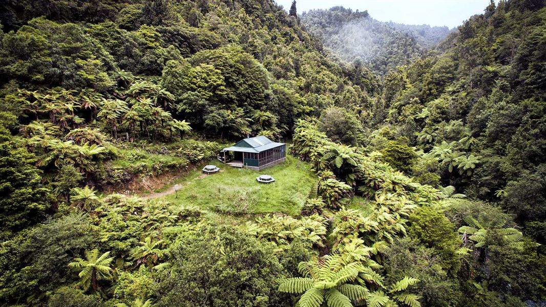
Stay in the heart of Barry Crump country in this classic backcountry hut.
On the way here
Pakihi Track · 6 - 7 hr
Mōtū Road to Pakihi Hut (10 km)
For cyclists, the start of the Pakihi Track is from the Mōtū Road, at close to 600 m altitude. There is a small shelter and a car-parking area. The top half of the track is a steady descent, dropping over 400 m to the Pakihi Hut. From the Mōtū Road to the hut, you cross 12 wooden bridges. It is thickly forested with trees including tawa, tōtara, rimu and rewarewa, however there are regular glimpses of far ridges. About 5 km in there are several 1.5 m wide cuttings across ridgetops. It’s impressive to think that these would have been dug by hand, over a century ago. There are two side-tracks down to the Pakihi Hut and the stream. They’re close together and clearly signed.
Pakihi Hut to Pakihi road end (9 km)
Beyond the Pakihi Hut, the next few kilometres are the most technical for riding, and the most liable to rock falls. Take care and follow all signs. Around 1 km after the hut you reach the Pakihi stream suspension bridge, a spectacular 32-m structure that spans a pretty gorge. On both banks, look for the remains of the abutments of the original bridge, built 1913/14 and wrecked in a massive storm in 1918. The lower half of the track is stunning, following the Pakihi stream all the way. You may see wild trout and birds including New Zealand falcon/kārearea, North Island robin, New Zealand woodpigeon/kererū and North Island weka. There are numerous small waterways, many falling in waterfalls. At the end of the track, there is a shelter, car park and toilet. Over the stream, Weka Wilds offers accommodation. Not far away in the Te Waiti Valley, there’s the Boulders Campsite . If you’re arranging to be picked up, it’s 23 km and a 30-minute drive from here to Ōpōtiki.
Source: DOC Te Papa Atawhai.
Fees and bookings
Before you go, buy Hut Tickets for each night's stay. Put these in the honesty box at the hut. Or buy a Backcountry Hut Pass that gives unlimited use at most Standard and Serviced huts for a 12 month period. Retailers that sell hut tickets and passes
Source: DOC Te Papa Atawhai.
Nearby stops
Wahaatua Hut
Bay of Plenty • 5.1 km

Te Waiti Hut
Standard • 6 bunks • Bay of Plenty • 5.6 km
Te Waiti Hut is a standard six-bunk hut located in the East Cape area of the Bay of Plenty.
Heating • Mattresses
Pakihi Heads Hut
Bay of Plenty • 6.8 km
Boulders Campsite
Basic • Bay of Plenty • 8.5 km
Boulders Campsite is located next to the Te Waiti Stream in the Bay of Plenty region. The site is surrounded by nikau palms and tawa forest, making it a…
BBQ • Non-powered/tent sites • Water from stream
Lagoon Hut
Bay of Plenty • 9.1 km
Walks nearby
Te Waiti Hut Walk
Advanced • 2 hr one way • 6.39 km away
Te Waiti Route
Expert • 6 - 8 hr one way • 8.83 km away
Manganuku Track
Advanced • 3-4 hr one way • 13.12 km away
Mangapumarumaru Track
Advanced • 3 - 4 hr one way • 13.54 km away
Whinray Scenic Reserve Track
Easy • 2 hr 30 min • 6.3 km • 13.81 km away
Contact
DOC Customer Service Centre
Regional DOC service centre.
Notes from people who have been
No notes yet. If you have been, say what you found.
Something missing or out of date?
Closed, moved, wrong facts, or something we have missed? Travellers keep the Road Guide up to date. Tell us what you found at contribute@parkup.nz and we will check it and add it.
Ask us to take this down
A person reads every request. We do not remove a place until we have checked it.
Sources
- OpenStreetMap Huts · ODbL (Open Database License)Contains information from OpenStreetMap, made available under the ODbL.
- DOC Huts (API) · CC BY 4.0Crown Copyright: Department of Conservation Te Papa Atawhai. Data sourced from the DOC Developer Portal (api.doc.govt.nz).
- DOC Huts · CC BY 4.0Data sourced from the Department of Conservation (DOC), New Zealand.