Mutton Creek Track
WalkOtagoOpen
- Grade
- Advanced
- Walking time
- 3 hr
- Distance
- 6 km
- Dogs
- Under control
Access: read before you go
Mutton Creek Track can be accessed from West Manuherikia 4WD Track and East Manuherikia 4WD Track.
Source: DOC Te Papa Atawhai.
Getting there
We have not checked a road end or car park for this place yet, so we do not give driving directions to it. Check how to get there before you go. Some routes cross private land and need the landowner's permission.
How to get there, on doc.govt.nzMutton Creek Track can be accessed from West Manuherikia 4WD Track and East Manuherikia 4WD Track.
Source: DOC Te Papa Atawhai.
Map
Map data © OpenStreetMap contributors. Topo map: LINZ, CC BY 4.0. 44.71646° S, 169.86519° E
Got a good photo of this place? Send it to us and we will show it with your name.
About this place
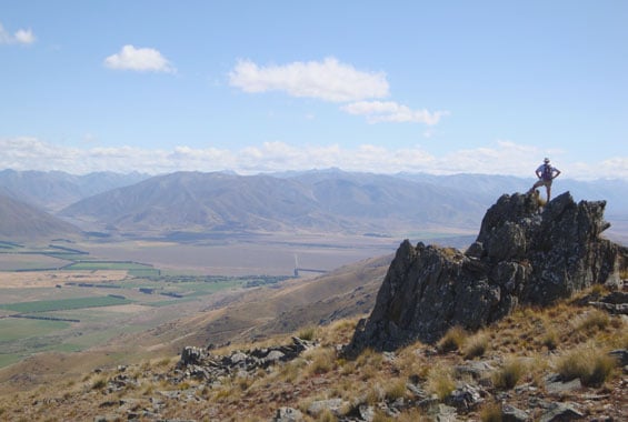
This track links the lower sections of the West and East Manuherikia 4WD Tracks.
The route
From the West Manuherikia 4WD Track, Mutton Creek Track climbs up and over a ridge and down to Mutton Creek. After crossing the stream, the track climbs over another ridge and descends to meet the East Manuherikia 4WD Track. It is a rough track with a steep climb at both ends. There are unbridged streams on the track. Assess these carefully before crossing and if in doubt, stay out. Loop options:
Source: DOC Te Papa Atawhai.
Know before you go
Pack the right gear
Take clothing for all weather – this includes packing warm, waterproof clothing and sun protection. Topographical maps are essential for all backcountry trips. Carry equipment for emergencies, including a torch, first aid kit, spare food and water, and something to use as an emergency shelter. Mobile phone coverage is not reliable. We recommend carrying a distress beacon. Walking and tramping gear lists
Be careful of rivers
If you plan to cross unbridged rivers, know how to cross safely and be prepared for if you cannot cross. Do not cross if the river is flooded, you cannot find safe entry and exit points or are unsure it’s safe. Turn back or wait for the river to drop. If in doubt, stay out. Be aware of weather conditions in the catchment headwaters. Check fords before entry. River safery – New Zealand Mountain Safety Council
No fires
Fires are not allowed anywhere in Oteake Conservation Park.
Check the weather forecast
Ida Railway Hut – NIWA Weather
Shared use tracks
Many of the tracks in Oteake Conservation Park are shared use. You may encounter walkers, mountain bikers, motor bikers and people riding horses. Take care and respect other track users.
Avalanches
Oteake Conservation Park has avalanche terrain. Be avalanche alert in Wakatipu, Wānaka and Central Otago
Source: DOC Te Papa Atawhai.

Nearby stops

Top Hut – Otago
Standard • 8 bunks • Otago • 6.5 km
Top Hut is an 8-bunk hut located in the Central Otago area.
Heating • Mattresses • Toilets - non-flush

Homestead Campsite
Basic • Otago • 6.9 km
Homestead Campsite is a basic, isolated campsite in Central Otago. It serves as a base for mountain biking, hunting, fishing, and tramping in the nearby St…
Non-powered/tent sites • Shelter for cooking • Water from tap - not treated, boil before use

Otamatapaio Hut
Standard • 4 bunks • Canterbury • 10.9 km
Otamatapaio Hut is a standard four-bunk hut located in the Mackenzie Country and Waitaki area of Canterbury.
Heating • Mattresses • Toilets - non-flush
Richmond Hut
Otago • 15.8 km
Richmond Hut is a backcountry hut located in the Otago region of New Zealand. The provided records do not include further details regarding its specific…
Walks nearby
Notes from people who have been
No notes yet. If you have been, say what you found.
Something missing or out of date?
Closed, moved, wrong facts, or something we have missed? Travellers keep the Road Guide up to date. Tell us what you found at contribute@parkup.nz and we will check it and add it.
Ask us to take this down
A person reads every request. We do not remove a place until we have checked it.
Sources
- DOC Tracks (API) · CC BY 4.0Crown Copyright: Department of Conservation Te Papa Atawhai. Data sourced from the DOC Developer Portal (api.doc.govt.nz).
- DOC Tracks & Trails · CC BY 4.0Data sourced from the Department of Conservation (DOC), New Zealand.