McConchies Hut
Standard hutKahurangi National Park, TasmanOpen
- Sleeps
- 4 bunks
- Booking
- Not bookable
- Cost
- from $15
- Heating
- Yes
- Drinking water
- Boil first
- Toilet
- Non-flush
Getting there
We have not checked a road end or car park for this place yet, so we do not give driving directions to it. Check how to get there before you go. Some routes cross private land and need the landowner's permission.
How to get there, on doc.govt.nzMcConchies Hut is accessible from the Matiri Valley and 1000 Acre Plateau tramping tracks.
- Topo map
- Topo50 sheet BR23
Source: DOC Te Papa Atawhai.
Map and tracks
Track lines: DOC Te Papa Atawhai. Map data © OpenStreetMap contributors. Topo map: LINZ, CC BY 4.0. 41.58748° S, 172.36429° E
About this place
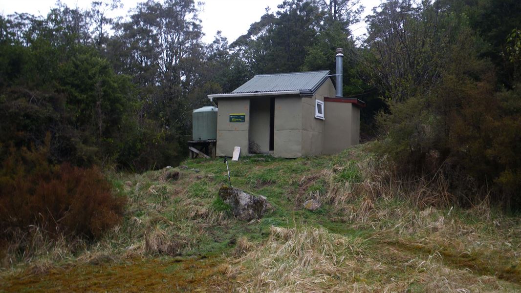
This is a standard 4-bunk hut in the Nelson Lakes area.
On the way here
Upper Matiri Valley and 1000 Acre Plateau tramping tracks
Lake Matiri Hut to McConchies Hut
Time: 9 hr Note: The track now takes 9 hr to walk due to fallen trees and overgrown vegetation.
Sidle around the western shore of the lake through beautiful beech forest. Just beyond the open flats where Bay Creek flows into the lake signs indicate the track to the 1000 Acre Plateau and the upper Matiri Valley. Continue up-valley on river flats for several kilometres. Travel slows as the valley narrows, two steep climbs avoid gorge sections. McConchies Hut is about half way up Matiri Valley.
McConchies Hut to Hurricane Hut
Time: 10+ hr Note: The track now takes 10+ hr to walk due to fallen trees and overgrown vegetation.
Beyond McConchies Hut, earthquake damage and diversion around obstacles on the valley floor make for slower going. Thirty minutes up river from the hut an unnamed side creek provides an arduous, unmarked route through bluffs to the tops near The Haystack. Continue up-valley until another side stream on the true right is reached. Leave the main valley here and head up the stream. Jumbled scrubcovered rocks require careful marker spotting. Eventually the track leaves the stream and climbs a slip to the ridge crest separating the side valley from the Matiri Valley. The track keeps to the ridge, eventually it drops off the western side of the ridge and emerges on to a boggy red tussock flat. Skirt the margin of the flat and climb over a forested saddle to another smaller swampy flat on the other side. Descend into a limestone stream bed which is often dry and follow it down to rejoin the Matiri River. A short climb leads to Lake Jeanette where drowned trees fringe a lake created by rockslides during the 1929 Murchison earthquake. Sidle the western shore of the lake and the western side of the now flat valley floor to reach Hurricane Hut.
Source: DOC Te Papa Atawhai.
Trip options
Walking times come from DOC track descriptions, added up leg by leg from car-accessible trailheads. Nights and return times are ParkUp estimates, allowing about 8 hours of walking a day.
1 option · 2 nights
Lake Matiri Hut
Walking in
15 hr (via Poor Petes Hut, Larrikins Creek Hut)
Walking out
15 hr to Lake Matiri Hut (via Poor Petes Hut, Larrikins Creek Hut)
Source: DOC Te Papa Atawhai track descriptions.
Fees and bookings
Before you go, buy Hut Tickets for each night's stay. Put these in the honesty box at the hut. Or buy a Backcountry Hut Pass that gives unlimited use at most Standard and Serviced huts for a 12 month period. Retailers that sell hut tickets and passes
Source: DOC Te Papa Atawhai.
On these tracks
Source: DOC Te Papa Atawhai.
Nearby stops

Poor Pete's Hut
Basic/bivvies • 2 bunks • Tasman • 4.6 km
Poor Pete's Hut is a basic two-bunk hut located in the Kahurangi National Park.
Mattresses • Toilets - non-flush • Water from tap - not treated, boil before use

Larrikin Creek Hut
Standard • 4 bunks • West Coast • 5.1 km
Larrikin Creek Hut is a standard four-bunk hut located in Kahurangi National Park.
Heating • Mattresses • Toilets - non-flush

Lake Matiri Hut
Standard • 8 bunks • Tasman • 8.1 km
Lake Matiri Hut is a standard 8-bunk hut located in Kahurangi National Park in the Tasman region.
Heating • Mattresses • Toilets - non-flush

Hurricane Hut
Standard • 4 bunks • Tasman • 9.1 km
Hurricane Hut is a basic 4-bunk hut located in the Nelson Lakes area of the Tasman region.
Heating • Mattresses • Toilets - non-flush
Contact
Nelson Lakes National Park Visitor Centre
Regional DOC service centre.
Notes from people who have been
No notes yet. If you have been, say what you found.
Something missing or out of date?
Closed, moved, wrong facts, or something we have missed? Travellers keep the Road Guide up to date. Tell us what you found at contribute@parkup.nz and we will check it and add it.
Ask us to take this down
A person reads every request. We do not remove a place until we have checked it.
Sources
- OpenStreetMap Huts · ODbL (Open Database License)Contains information from OpenStreetMap, made available under the ODbL.
- DOC Huts (API) · CC BY 4.0Crown Copyright: Department of Conservation Te Papa Atawhai. Data sourced from the DOC Developer Portal (api.doc.govt.nz).
- DOC Huts · CC BY 4.0Data sourced from the Department of Conservation (DOC), New Zealand.