Gold Creek Hut
Basic/bivvies hutRuahine Forest Park, Hawke's BayOpen
Current advisories
Predator control for Ruahine Forest Park – north-east Ruahine
05 March 2026
Toxic bait containing 1080 was distributed in the north-western area of Ruahine Forest Park on 5 March 2026. Treatment blocks can be viewed on DOC's pesticide summary . It is not safe to hunt for food or have your dog in this area for up to 8 months. Warning signs and this web alert will be removed once the area is safe again. This operation is part of DOC's National Predator Control Programme to protect native species. First published on 7 January 2026. Last reviewed on 6 March 2026.
Source: DOC Te Papa Atawhai alerts.
- Sleeps
- 4 bunks
- Booking
- Not bookable
- Heating
- Yes
- Drinking water
- Not drinkable
- Toilet
- Non-flush
Getting there
We have not checked a road end or car park for this place yet, so we do not give driving directions to it. Check how to get there before you go. Some routes cross private land and need the landowner's permission.
How to get there, on doc.govt.nzGold Creek can be accessed from the Wakarara Roadend. This is approximately 75km from Napier. Turn onto Wakarara Road from SH50 and follow for approximately 26.5km to the end of Wakarara Road. Continue along the road past the Parks Peak Station sign to the carpark, indicated by DOC signs. Park to the left of the road at the indicated area, before the gate. Please park well off the road and be mindful of farming operations that are being carried out.
From the carpark, follow a poled route (marked with orange track markers) for approximately 500m along the farmers fence line and through a paddock down to the river. Head upstream to the Ruahine Forest Park boundary by following the wide river valley to the Gold Creek junction. Climb up the true right bank of Gold Creek where a memorial plaque and a DOC sign marks the start of the route. At this point, go through the farm gate and climb the steep slope following the fence-line until the ground levels off and passes through a small pedestrian gate.
A well-marked track follows the gently graded ridge through beech forest. The track turns sharply off the ridge once past spot height 984m. The descent into Gold Creek begins gently and steepens closer to the creek. The creek is usually a gentle ford, however after heavy rain or additional snowmelt the creek can become swift and hazardous. The river route down Gold Creek to the Makaroro River is not recommended, as it has deep pools and gorges. Return via the track to the Makaroro River.
Gold Creek Hut is located on a small gravel bench on the true left of Gold Creek at an altitude of 710 metres.
- Topo map
- Topo50 sheet BK36
- Grid reference
- E1873798, N5593735
Source: DOC Te Papa Atawhai.
Map and tracks
Track lines: DOC Te Papa Atawhai. Map data © OpenStreetMap contributors. Topo map: LINZ, CC BY 4.0. 39.76183° S, 176.19717° E
About this place
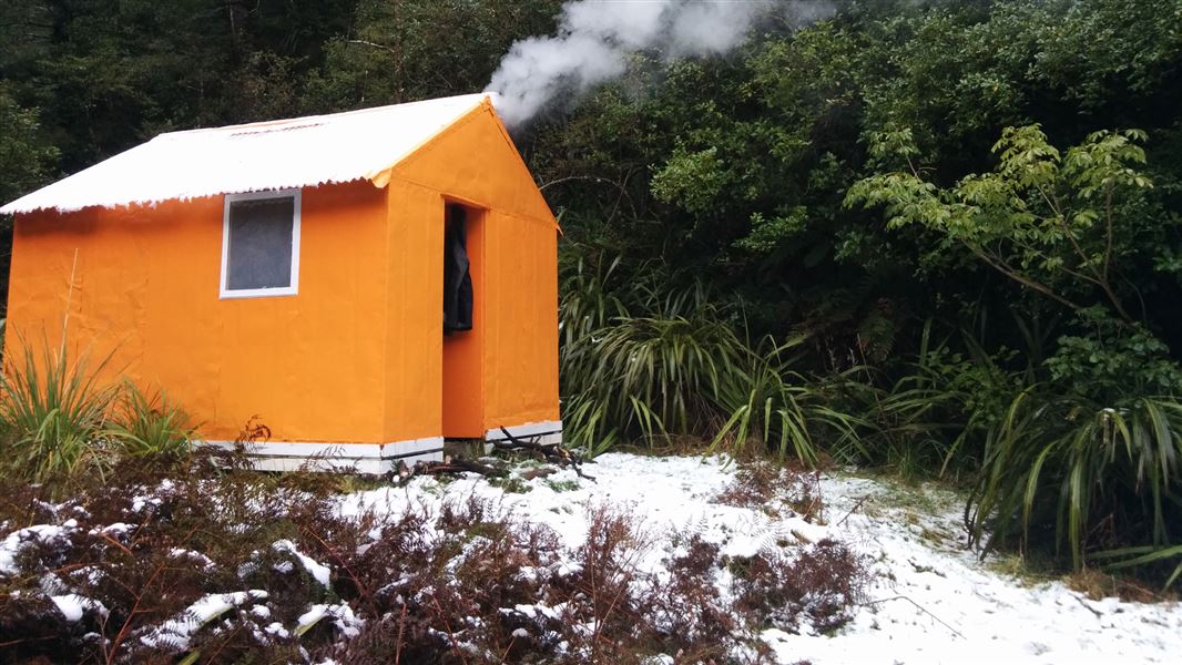
This is a basic four-bunk hut in the Hawke's Bay region.
Fees and bookings
Free
Source: DOC Te Papa Atawhai.
Nearby stops

Sparrowhawk Bivvy
Basic/bivvies • 2 bunks • Hawke's Bay • 3.1 km
Sparrowhawk Bivvy is a basic two-bunk hut located in the Hawke's Bay region.
Mattresses • Toilets - non-flush • Water from tap - not treated, boil before use
Norris Hut
Hawke's Bay • 3.6 km
Norris Hut is a backcountry hut located in the Hawke's Bay region. The provided data does not include further details regarding its specific facilities or…

Top Maropea Hut
Basic/bivvies • 4 bunks • Manawatū-Whanganui • 3.6 km
Top Maropea Hut is a basic four-bunk hut located in the Manawatu region.
Heating • Mattresses • Toilets - non-flush

Triplex Hut
Standard • 12 bunks • Hawke's Bay • 3.6 km
Triplex Hut is a standard 12-bunk hut located in the Hawke's Bay region.
Heating • Mattresses • Toilets - non-flush

Sunrise Hut
Serviced • 20 bunks • Hawke's Bay • 3.8 km
Sunrise Hut is a serviced twenty-bunk hut located in the Hawke's Bay region.
Heating • Mattresses • Toilets - non-flush
Walks nearby
Contact
DOC Customer Service Centre
Regional DOC service centre.
Notes from people who have been
No notes yet. If you have been, say what you found.
Something missing or out of date?
Closed, moved, wrong facts, or something we have missed? Travellers keep the Road Guide up to date. Tell us what you found at contribute@parkup.nz and we will check it and add it.
Ask us to take this down
A person reads every request. We do not remove a place until we have checked it.
Sources
- DOC Huts (API) · CC BY 4.0Crown Copyright: Department of Conservation Te Papa Atawhai. Data sourced from the DOC Developer Portal (api.doc.govt.nz).
- DOC Huts · CC BY 4.0Data sourced from the Department of Conservation (DOC), New Zealand.
- OpenStreetMap Huts · ODbL (Open Database License)Contains information from OpenStreetMap, made available under the ODbL.