Omahuru Campsite
Standard campsiteLocated in Te Urewera, Bay of PlentyOpen
Current advisories
Te Urewera alerts
05 June 2026
Check Ngāi Tūhoe website for alerts before your trip. Alerts will be not typically be posted on this website. Visitors can also phone Ngāi Tūhoe on +64 6 837 3803 or email teureweravc@ngaituhoe.iwi.nz for information. First published on 17 October 2022. Last reviewed on 6 June 2026.
Source: DOC Te Papa Atawhai alerts.
- Sites
- 40
- Booking
- Not bookable
- Cost
- from $10
- Power
- None
- Toilet
- Yes
- Water
- Yes
- Dogs
- No dogs
Getting there
Follow Bell Rd off SH2 near Waimana and then onto Matahi Valley Rd. The campsite is 18 km from SH2.
Access: Gravel mid-Matahi Valley Rd.
Source: DOC Te Papa Atawhai.
Map
Map data © OpenStreetMap contributors. Topo map: LINZ, CC BY 4.0. 38.31270° S, 177.12122° E
About this place
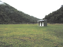
Camp, swim, fish, or relax beside the river in the Waimana valley. Take your binoculars for birdwatching.
Fees and bookings
The DOC Campsite Pass cannot be used at this campsite.
Source: DOC Te Papa Atawhai.
Nearby stops
Te Pakau
Bay of Plenty • 2.7 km
Onepu Hut
Bay of Plenty • 5 km
Heating • Mattresses • Toilets - non-flush

Te Pakau (Eight Acre) Campsite
Basic • Bay of Plenty • 5.7 km
Te Pakau (Eight Acre) Campsite is located in the Bay of Plenty near the Waimana River. The site was formerly a dairy farm and offers access to numerous walks…
Fire pit/place for campfires (except in fire bans) • Non-powered/tent sites • Water from stream
Koaunui Hut
Bay of Plenty • 6.1 km
Heating • Mattresses • Toilets - non-flush
Ohora Hut
Bay of Plenty • 9 km
Ohora Hut is a Department of Conservation hut located in the Bay of Plenty region.
Heating • Mattresses • Toilets - non-flush
Contact
Te Urewera Visitor Centre
Te Kura Whenua, 6249 Lake Road/SH38, Waikaremoana 4195, Te Urewera
Regional DOC service centre.
Notes from people who have been
No notes yet. If you have been, say what you found.
Something missing or out of date?
Closed, moved, wrong facts, or something we have missed? Travellers keep the Road Guide up to date. Tell us what you found at contribute@parkup.nz and we will check it and add it.
Ask us to take this down
A person reads every request. We do not remove a place until we have checked it.
Sources
- DOC Campsites · CC BY 4.0Data sourced from the Department of Conservation (DOC), New Zealand.
- OpenStreetMap Campsites · ODbL (Open Database License)Contains information from OpenStreetMap, made available under the ODbL.
- DOC Campsites (API) · CC BY 4.0Crown Copyright: Department of Conservation Te Papa Atawhai. Data sourced from the DOC Developer Portal (api.doc.govt.nz).