Martins Bay Hut
Serviced hutFiordland National Park, SouthlandOpen
Current advisories
Pest control operation for Martins Bay
05 July 2026
The Hollyford Conservation Trust is running a bait station operation in Martins Bay. Toxic bait may be present from 7 July 2026 to 28 February 2027. Warning signs are in place throughout the project area. For more information, check the pesticide summary . First published on 7 July 2025. Last reviewed on 6 July 2026.
Significant treefall between Demon Trail Hut and Hokuri Hut
28 September 2026
There is significant treefall along the track section between Demon Trail and Hokuri huts. Fallen trees and slips will require sections of off-track navigation and should only be attempted by experienced trampers. Proceed with caution and allow extra time. First published on 10 February 2026. Last reviewed on 29 September 2026.
Source: DOC Te Papa Atawhai alerts.
- Sleeps
- 24 bunks
- Booking
- Can book
- Cost
- from $10
- Heating
- Yes
- Drinking water
- Boil first
- Toilet
- Non-flush
Getting there
We have not checked a road end or car park for this place yet, so we do not give driving directions to it. Check how to get there before you go. Some routes cross private land and need the landowner's permission.
How to get there, on doc.govt.nz- Topo map
- Topo50 sheet CA09
Source: DOC Te Papa Atawhai.
Map and tracks
Track lines: DOC Te Papa Atawhai. Map data © OpenStreetMap contributors. Topo map: LINZ, CC BY 4.0. 44.33507° S, 168.00321° E
About this place
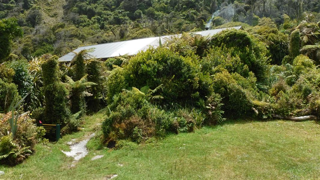
This is a serviced 24-bunk hut in northern Fiordland.
On the way here
Hollyford Track · 4–5 days
Hokuri Hut to Martins Bay Hut
Time: 4–5 hr
km Walk for 30 min from Hokuri Hut to reach Hokuri Creek. In low river conditions, you can cross near the creek mouth, but otherwise should use the three-wire crossing 20 min upstream. After crossing the creek, follow the lake shore past the bay where the settlement of Jamestown once stood. After a further 1.5–2 hr walk, the track leaves the lake and continues for another hour to the Hollyford Airstrip and Martins Bay Lodge, managed by Hollyford Track Guided Walks. Martins Bay Hut, situated at the mouth of the Hollyford River/Whakatipu Kā Tuka, is a further 1.5–2 hr from Martins Bay Lodge turn off. Take care when crossing Jerusalem Creek as it is prone to flooding after rain. The track continues on to Long Reef through wind-shorn forest and provides views of the river mouth and sand spit. From July to November, seals and tawaki / Fiordland crested penguins can be seen around the coast close by The track continues on to Long Reef through wind-shorn forest and provides views of the river mouth and sand spit. From July to November, seals and Fiordland crested penguins/tawaki can be seen around the coast close by. Beyond Long Reef, the track becomes the Pyke - Big Bay Route . This route is not as well defined and suitable only for well-equipped and experienced trampers.
Pyke - Big Bay Route
Big Bay Hut to Martins Bay Hut
4 - 5 hr, 16 km This section initially follows the sandy beach from Big Bay to McKenzie Creek, located at the southern end of the bay. After crossing the creek (take care as McKenzie Creek can often be impassable and extremely dangerous after rain), a short track leads to the coast. Follow the coastline to Long Reef, before joining the track to Martins Bay Hut (24 bunks) and the Hollyford Track. The route between Martins Bay Hut and Big Bay Hut near Long Reef is overgrown and has a small slip on it making it difficult to navigate. It's recommended that trampers walk around the coast, but this can only be done 2 hours either side of low tide and with calm sea conditions. Be aware there may be seals in this area. The Hollyford Track then follows the true right of the Hollyford River/Whakatipu Kä Tuka, and after about an hour’s walk, reaches private dwellings and two airstrips.
Martins Bay Hut to Hollyford Road End (via Hollyford Track)
4 days, 56 km For details see Hollyford Track .
Source: DOC Te Papa Atawhai.
Know before you go
Requirements for taking a vessel into Fiordland Marine Area
The Fiordland Marine Pathway Plan protects the area from marine pests which can be carried in on boats. It sets out rules and standards that must be met by all vessels entering within one nautical mile of the landward boundary of the Fiordland Marine Area. If you take a vessel into Fiordland from outside the area you must: apply for a Clean Vessel Pass , and ensure that hulls are clean of marine pest species. The plan is an Environment Southland regulation. DOC has no authority below mean high tide except in marine reserves or concerning marine mammals – we do not enforce any fishing regulations. More information about the Fiordland Marine Pathway Plan . See the Fiordland by Sea: A guide to the Fiordland (Te Moana o Atawhenua) Marine Area - including maps, anchorages and fishing regulations.
Source: DOC Te Papa Atawhai.
Trip options
Walking times come from DOC track descriptions, added up leg by leg from car-accessible trailheads. Nights and return times are ParkUp estimates, allowing about 8 hours of walking a day.
1 option · 3 nights
Hidden Falls Hut
Walking in
19 hr (via Lake Alabaster Hut, Demon Trail Hut, Hokuri Hut)
Walking out
19 hr to Hidden Falls Hut (via Lake Alabaster Hut, Demon Trail Hut, Hokuri Hut)
Source: DOC Te Papa Atawhai track descriptions.
Fees and bookings
1 May - 30 September
1 October - 30 April
Weekdays
Weekends
1 December - 29 February
Weekdays
Weekends
Camping
Before you go, buy Hut Tickets for each night's stay. Put these in the honesty box at the hut. Or buy a Backcountry Hut Pass that gives unlimited use at most Standard and Serviced huts for a 12 month period. Retailers that sell hut tickets and passes
Bookings are open for stays up to 30 June 2027. If no availability shows online for your dates, the hut is fully booked. No spaces are kept for visitors arriving without a booking. Phone and in‑person bookings made at a visitor centre incur a $10 service fee. Same‑day bookings are available online until 8 pm if spaces remain.
Source: DOC Te Papa Atawhai.
On these tracks
Source: DOC Te Papa Atawhai.
Nearby stops
Big Bay Hut
Standard • 9 bunks • Southland • 9.8 km
Big Bay Hut is a standard nine-bunk hut located in northern Fiordland.
Heating • Mattresses • Toilets - non-flush

Hokuri Hut
Serviced • 12 bunks • Southland • 10.4 km
Hokuri Hut is a serviced 12-bunk hut located in northern Fiordland.
Heating • Mattresses • Toilets - non-flush

Demon Trail Hut
Serviced • 12 bunks • Southland • 18.5 km
Demon Trail Hut is a serviced 12-bunk hut located in northern Fiordland.
Heating • Mattresses • Toilets - non-flush
Olivine Hut
Standard • 6 bunks • Southland • 20.6 km
Olivine Hut is a standard six-bunk hut located on the border of Fiordland and Mount Aspiring National Parks and the Pyke Forest Conservation Area.
Heating • Mattresses • Toilets - non-flush
McKerrow Island Hut
Standard • 12 bunks • Southland • 20.9 km
McKerrow Island Hut is a standard 12-bunk hut located in northern Fiordland.
Heating • Mattresses • Toilets - non-flush
Contact
Te Rua-o-te-moko/Fiordland National Park Visitor Centre
1 Lakefront Drive, Te Anau 9600
Regional DOC service centre.
Notes from people who have been
No notes yet. If you have been, say what you found.
Something missing or out of date?
Closed, moved, wrong facts, or something we have missed? Travellers keep the Road Guide up to date. Tell us what you found at contribute@parkup.nz and we will check it and add it.
Ask us to take this down
A person reads every request. We do not remove a place until we have checked it.
Sources
- OpenStreetMap Huts · ODbL (Open Database License)Contains information from OpenStreetMap, made available under the ODbL.
- DOC Huts (API) · CC BY 4.0Crown Copyright: Department of Conservation Te Papa Atawhai. Data sourced from the DOC Developer Portal (api.doc.govt.nz).
- DOC Huts · CC BY 4.0Data sourced from the Department of Conservation (DOC), New Zealand.